Water in California
California’s water system is large, complex, and interconnected. Most precipitation falls in the northern and mountainous regions of the state during the winter, but most people live along the coast, especially in the south. While precipitation falls in the winter, most demands, including agriculture and urban irrigation, occur in the spring and summer. Precipitation also varies across years, making the state susceptible to large floods and prolonged droughts. These conditions led over decades to the development of vast infrastructure systems that move water to demand centers and protect residents from flooding.
Most of the rain that falls in the state evaporates, leaving less than half of total annual rainfall that runs off into streams, rivers, and groundwater basins. The state supplements available supplies from runoff through water imports from other states, groundwater mining, and limited use of recycled and desalinated water.
| A view of California's statewide water infrastructure as depicted in the CALVIN model. Photo Courtesy of UC Davis Center for Watershed Sciences |
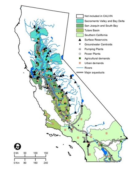 |
Hightly engineered infrastructure systems throughout California move this water. Most north-south transfers flow through the canals and aqueducts of two large projects: the State Water Project (SWP) and the Central Valley Project (CVP). The SWP includes the large east and west branches of the California Aqueduct. In the center of the state lies the Sacramento-San Joaquin Delta, one of the largest inland estuaries in the world. The vast network of dams, canals, streams, rivers, and pumping plants pushes water to the areas of higher demand for agriculture and urban end-uses.
Southern California typically receives more than 1 million acre-feet of imported water each year (One acre-foot of water covers a football field to a depth of one foot). The Los Angeles region gets limited precipitation, usually 10 inches per year, in the coastal plain where everyone lives, though some areas in the surrounding mountains can receive up to 40 inches of snow and rain annually. The region captures some of this runoff through large stormwater capture basins that spread water in sink it into the ground. These capture basins, which have operated for decades, recharge an average of 200,000 ac-ft of water each year.
Despite the work to utilize local supplies, most water is still imported from other parts of the state or country. The City of Los Angeles receives water through the Los Angeles Aqueduct that connects the Owens Valley and Mono Lake. Throughout the region, the Metropolitan Water District of Southern California (MWD) imports water from two primary sources: the Colorado River Aqueduct originating at Parker Dam along the California-Arizona border, as well as via the State Water Project bringing runoff from Northern California through the Sacramento-San Joaquin Delta.